Monday, November 28, 2011

Lab 10: Mitochondrial Eve

One could say she's the Mother of Modern Humanity and it would not be hyperbole. Mitochondrial Eve is where all Homo Sapien gets its mitochondrial dna. This tells us some very important things about humans, and enables science to trace our path from obscure North African tribe to the dominant species on Earth.

It's been a long road.

The reason we can trace our ancestry all the way back to the first modern human is Mitochondria, an organelle located in the cells of all humans. This small, bean-shaped organelle supplies energy to the cell for it to work more efficiently. We can use this to trace our lineage because of the unique Mitochondrial DNA inside the organelle, completely different from the rest of the cell's DNA. This information, unlike normal gene transfers which use both mother and father DNA, is purely matriarchal. One Hundred Percent of the DNA in a mitochondria is derived from the mother of the child. This gave scientists the ability to trace the path of humanity from it's first beginnings to it's spread across the entire globe (See map above).

If nothing, those little bean-shaped organelles have shown the scientific community that no matter how disparate we look and how different our languages are we are all from the same place and are part of the same family.

Lab 9: Dog Parks

When discussing Environmental Sciences it is important to remember the every day implications of humanity's interaction with nature. Dumping chemicals from a factory could ruin an entire watershed, clear cutting can erode away all fertile soil in an area and leave it barren, and what is the connection between the emissions from the cars that drive past your house and your garden in the back yard? Dog Parks are yet another scenario where Humans and Nature meet with unexpected consequences.

Socially, Dog Parks are a great way to allow your pet to get exercise, meet other dog lovers, and enjoy the outdoors. However, they are not immune to the environmental variables that affect so much of our daily lives. At the Macon Dog Park, for example, there is a small creek that runs through it. This creek is runoff from a neighborhood nearby, and is subject to contaminants from garbage on the side of the road, car exhaust, biological matter from other animals, and chemicals that might be dumped by an irresponsible person such as anti-freeze or motor oil.

Anti-freeze? In my water? It's more likely than you think.

To further delve into this topic, the dogs themselves are a risk to one another. Dogs attacking other dogs, dogs eating the feces of other dogs, dogs giving other dogs diseases, it's pandemonium. One of the largest threats to the safety of dogs in these large group gatherings is the Parvovirus. According to Wikipedia: "Canine parvovirus is a particularly deadly disease among young puppies, about 80% fatal, causing gastrointestinal tract damage and dehydration as well as a cardiac syndrome in very young pups. It is spread by contact with an infected dog's feces. Symptoms include lethargy, severe diarrhea, fever, vomiting, loss of appetite, and dehydration." It's important to take notice of such biological issues that could arise from something as simple as going to the dog park, as well as the environmental impacts that can shape and affect unsuspecting animals in even the most controlled of environments.

Lab 8: Darwin's Dilemma

The Burgess Shale is a fossil bed in the Canadian Rockies which contains one of the largest collection of fossils in the world, is known for having numerous soft-body fossils, and is one of the oldest at 505 million years old. This fossil collection gave science an unprecedented look into life in the Cambrian era, where macro-organisms first became prevalent on Earth and set the stage for later evolution into the creatures we know today.

The Cambrian Period is where large animals first took over the Earth, and it was an explosion of new types of life that had never before been seen. Where Pre-Cambrian biota was largely bacteria and some smaller hard-shelled creatures, the Cambrian was lush with many different types of creatures that we today would consider beyond bizarre.
Hallucigenia: A creature so strange it was first reconstructed upside down. There really is no modern analog to this strange Cambrian creature.

Charles Darwin studied the Cambrian Era as an undergrad at Cambridge in Whales, where the first Cambrian fossils were excavated. Throughout the crafting of his Theory of Evolution, Darwin acknowledged that the Cambrian Era posed particular challenges that had to be explained for this Theory to work properly. At the beginning of the Cambrian, there was an explosion of new life in a relatively short period, one that seems to be too short for evolution to work, and the extreme diversity of life cannot currently be accounted for using the Theory of Evolution. According to Darwin, life starts with a small number of phyla, and then diversifies over millions of years. But, in the Cambrian Explosion, the Earth went from a few crab-like creatures and bacteria to having an extremely diverse range of creatures with no real obvious explanation.  In the Prologue of Origin of the Species, Darwin admits that if there were to be a new discovery in paleontology to dispute his theory it would be from the Cambrian period, and that the diversity of life in the Cambrian would be a valid rebuttal of his ideas.

The Burgess Shale continues to pour a wealth of information into the scientific community, forcing us to constantly look and adjust our worldview about the origins of life on Earth and how we came to be. 

Monday, November 14, 2011

Lab 6: Jackson Springs

Jackson Springs Park, and the surrounding area, was the first suburb in Macon and is now a private park. Our main purpose was to explore the geological diversity of the area and learn a bit about the history of this place.

We began with a hike around the park, picking up different rocks as we went, and Dr. Rood explained some of the history of the Park. It was once huge, encompassing most of the neighborhood surrounding it as well as the Baconsfield shopping center. Slowly, land development encroached on the natural beauty of the area as stores went up. At the same time, the land was being subdivided into lots for home development, which removed many of the old trees in the area for space and for use as energy in homes. Now, the park is just a small sliver hidden away in the Jackson Springs suburb.

The rocks we found were varied and gave us a chance to compare many of the samples we'd seen in class. I myself found a very bright pink Feldspar, while some of my other classmates were able to pick out Gneiss, Granite, Slate, and during our adventure we were able to see the ground strata of the area due to erosion by a stream nearby. Overall, the lab gave me insight into the history of my own hometown, and we got to actually get hammers in our hands and open some rocks, which made identification of the rocks during the test much easier.

Monday, October 31, 2011

My Favorite Lake: Plitvice Lakes

This is a set of natural features I would actually go to Croatia to see: the Plitvice Lakes!


They're a large set of lakes interconnected by waterfalls. It's in the center-western section of Croatia.

Lab 4: Ocmulgee Indian Mounds: Who were the Mound-Builders?

The Ocmulgee National Monument represents over 17,000 years of human habitation in the Macon area. Many different people lived, farmed, traded, and fought on these lands, all the while forming a great civilization as evidenced by the earthworks still around today. The Mississippians Culture is responsible for the cultivation of this land and the creation of one of the largest trade networks in the ancient world, but who were the Mississippians?

The Mississippian Culture originated in the Mississippi River valley, with their oldest discovered earthwork dated at around 3500 BCE. The people moved and spread, forming small villages and cities all around the Southeastern United States. They built large earthwork fortifications against enemies, as well as temples and earth lodges for spiritual and political affairs.


The cultural history of this place is vast, with inhabitants from  900-1150 BCE they left a large number of artifacts behind to tell their story. Arrowheads, work tools, jars and other pottery all have been discovered within the park and point to a long scale habitation. The Ocmulgee National Park has given us modern day people a glimpse into the past, at how people used to live and their beliefs and practices. By looking into the past we can attempt to find out more about what it means to be a human in the here and now, and the Ocmulgee National Monument makes a profound statement about the longevity of Humanity and how even with the most basic tools and practices can create sophisticated works of architecture.

Negative Feedback Loops: Matter and Anti-Matter

A negative feedback loop is when the output of a system acts to oppose the input of a system, forcing the system  back to it's original state. This is extremely important for the preservation of natural systems on Earth, such as the  Nitrogen Cycle or the Water Cycle.

Another, albeit much stranger, feedback loop doesn't occur on Earth at all. It occurs only in the deepest vacuum, when there are no other particles.

Virtual Particles are the manifestations of "vacuum energy" that is found in the space where the vacuum is. Because energy can turn into matter, via Einstein's Theory of Relativity, the vacuum energy turns into two opposing Virtual Particles: A piece of Matter and Anti-Matter. The two particles have a mass, exist in time, and once are created destroy each other and return to being energy.

This can be tested in a lab using a vacuum and two metal plates parallel to each other. When the vacuum is created, the vacuum energy begins to form into virtual particles. The visual effect is that the two metal plates will slightly bend away from each other as the force of the Virtual Particles coming into and leaving existence push the bars apart.

Virtual Particles are a great example of a negative feedback loop because it demonstrates a return to the original form that the system starts in. First we have a vacuum, followed by the creation of particles, the destruction of particles, and then a return to a pure vacuum state again.

These virtual particles are the same as described in Stephen Hawking's Black Hole Theory and the presence of "Hawking Radiation". Hawking described Black Holes as having a spout of particles coming out of it from both sides even though a Black Hole is supposed to absorb everything. What Hawking deducted was that these virtual particles were forming at the event horizon, or 'Point of No Return', of black holes. One of the particles formed would be sucked into the black hole, while the other would be shot away thanks to the myriad of forces surrounding a Black Hole. This is what he hypothesized was making the spout out of the Black Holes he was describing.

Although quantum physics doesn't always adhere to the normal Natural Laws that macro-organisms and other bodies have to obey, it is still an important part of nature and helps to drive many of the important mechanisms of Life and the Cosmos at large.

Monday, October 10, 2011

Ultisol: The Soil of the South.

There are 12 soil types around the world. Each type has a very special role to play in the ebb and flow of materials around the world. My favorite soil would have to be one that I interact with fairly regularly, that helps me to get most of my food intake, and that I've at least dug into once in my life. That soil would be Ultisol.

Ultisol is a soil type that covers most of the southern United States. It is an acidic forest soil with low amounts of Potassium, Carbon, and Magnesium. This soil type is usually indicative of old stable climates since it's been leeched of K, Ca, and Mg, and is usually found in tropical climates. It has a layer, or horizon, of clay that is very thick and of various colors between grey and red with the red being indicative of Iron oxides in the soil.This type of soil is good for forests, as the soil is rich. The soil isn't as good for sustained agriculture without fertilizers because of the nutrients being leeched from the soil, but this can be corrected with adequate fertilizer use. Georgia and China have many things in common in the natural world due to having similar latitudes, and can share certain plant species. Georgia and Southern China also share the Ultisol soil type, which is also prevalent in parts of Africa and South America.

Soil, Gardens, and the people who love them.

This past lab was an introduction into the world of soil science, and to do this we went to the Centenary United Methodist Church across the street from Mercer University.

With a few soil sampling tools, we headed to a small grassy field covered in red ants to dig some holes and take some soil samples. Using our soil consistency chart, we were able to determine the overall sand-clay-soil content, we dug down to the clay layer, and we took some core samples with a "Split Spoon Corer" of the field in order to better view the various layers. The field itself was of very rich soil with a thick clay deposit about a foot underneath. *I haven't been given pictures of that day from my classmates yet, so no fun pictures*

After we were done exploring and sampling the soil, we put it into a Sieve to learn about grain size in soil. A sieve is a tool used to separate different soil particules using mesh screens. The screens are numbered Dxx, where the xx is equal to the percentage of soil that will pass through the sieve. Unfortunately when we went to dig it had just rained, so a lot of the soil we attempted to sift through just clumped into little balls at the top and very little of it made it to the bottom tiers.

After our sieving we took a quick trip to the conveniently placed community garden nearby, where we talked about a few of the challanges facing community gardens. One of the major challanges is Lead, which is a common contaminant in the soil of urban areas. For this reason, the community garden had raised beds for their plants, effectively separating their plants from the lead contamination. Another round with the split spoon corer revealed an extremely thick soil that a few people had trouble getting all the way through. The difficulty was revealed after I was able to actually get the corer down in to the ground, as I brought up my core tool I realised we had a white layer that was thick and difficult to get through. Dr. Rood revealed it to be kaolin, an essential trade mineral here in Georgia thats used for a plethora of things. *More pictures of us with our core samples*

Overall this was a great foray into the world of soil sciences, and as always with Dr. Rood we made sure to get our hands dirty.

Wednesday, October 5, 2011

Lab 3: Shrubs and Such

For this lab we ventured out into the wilderness known as Mercer University Campus to learn about our leafy neighbors, the plants and trees. I'll detail some of the species we saw on our trek.

Yoshino Cherry Tree, Prunus Yeodoensis
This tree grows mainly in Japan, Washington D. C., and here in Macon. It's a flowering tree with beautiful red to white blossoms.

Sycamore Maple tree, Acer Pseudoplatanus

One of the many various Acer genus trees that are across Mercer. This tree has a characteristic leaf pattern and is common in Europe, Asia, and North America with about 129 species of the Acer genus around the world.

Oak, the genus Quercus (Quercus Robur shown in picture)
The oak genus is extremely expansive with about 600 species, many of which are in the Northern Hemisphere. It has various leaves although the picture above shows the average oak's leaf shape, and they drop acorns to propagate.

Chinese Chestnuts, Castanea mollissima
The chinese chestnut is, well, from china and was brought here to North America after the fungal disease chestnut blight killed almost all of the chestnut trees here in Macon. They drop their chestnuts inside of spiney skins and the nut isn't as desired as the American Chestnuts' due to the nuts not being as sweet.

Larch Pine, genus Larix


The Larix genus is a coniferous tree similar in shape to what westerners think of as a "Christmas Tree".

Ageratum, genus Ageratum
While beautiful, the genus Ageratum is considered to be an endemic weed in the East United States, and can be toxic in large quantities to farm animals. It hosts a flurry of different colors that can be cultivated and used as garden flowers or decorative flowers.

Elephant Ear, Angel's Wings, Heart of Jesus, etc : genus Araceae
This decorative plant has been used to spruce up gardens and fence lines since the 18th century. Its colors can vary from red to white to green and are very common.

Holly, genus Ilex


Hollys are of the genus Ilex and range from 400 to 600 species of plant. Many have barbed leaves and small berries that grow on them.


Poison Ivy, Toxicodendron radicans
This innocuous plant is the bane of many a suburban mom's lives. Poison ivy delivers a toxin called urushiol that causes break-outs in other animals. This is a mechanism for protecting the plant against deer and other plant predators.

Hydrangea, genus Hydrangea
Hydrangeas are a genus of about 70 different species, from trees to shrubs to flowers to climbing vines. They have a myriad of colors and come in two main flower varieties. The one pictures is the lacecap flower style, while there is another called the mophead style where the flowers are poofy and bundled close together to resemble a common household mop.

Thursday, September 22, 2011

Lab 2: Down the Ocmulgee River

For this trip we measured the depth of the Ocmulgee River in downtown Macon and too soil samples to count the amount of clams we could find.


Here's the basic transect line we used when we were measuring the River. Here are the results:

To give you an better idea as to the conditions we were operating under, he's a picture I found of Macon in 2007 from Google Earth:

As you can see, the sandbar in the middle has been reduced to two smaller ones. In this picture you can see more readily why the clam populations found in the Ocmulgee would make more sense.

Here's the Clam Data:

Compare the locations of the clams with the 2007 map and you'll see the clams tend to live best when in a location with good current but shallow water, such as the 5 marks at the top and the higher marks towards the opposite of the River on the western side. These locations had shallow water, but water that moved faster than the 0 marks or 2 marks.

To give some Non-Maconites an idea of what the River has looked like in the past, here's our transect line in 1994 a few months before the Flood.

Notice no sandbar at all, and the relative height of the river compared to the field that would later become part of the RiverWalk towards the North of the Transect Line. When Macon's not in the middle of a horrid drought, the Ocmulgee can be a very powerful and full river.

Well, that's the 2nd Lab in this class, feel free to comment!

Thursday, September 8, 2011

Cartography Lab part 3

For this assignment I was to create a map with symbols on Googleearth.

Here I have my approximately 2 mile sphere of influence. Being that I don't have much money I can't exactly go very far, so I mostly stay inside of downtown. The path you see is my commute from School to Work and back, and the pushpins are places I've been employed at. My current employer is in the Fickling Building.

Cartography Lab part 2

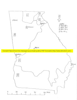
In this section, Dr. Rood decided to have us hand-draw a map of Georgia and it's precipitation zones in an Isametric style. Here's mine:


Due to overzealous software developers, I have a horrific yellow stripe across my beautiful drawing, but unfortunately that was my only choice since Blogger can't have the decency to take PDF files.

Cartography Lab part 1

In this week's lab we learned about maps and how they're used to help us visualize and convey information.

The first type is an Isarithmic Map. An Isarithmic Map is used for visualizing zones with different characteristics. Here is a map of Africa showing the various zones of population density:

The next type of map is a Chloropleth map. This map is a type of Isarithmic map, but it's based in units for a whole area, similar to election state maps. Here's a map of Female to Male ratio per state:

This next map is a Proportional Symbol Map. This type of map uses a symbol, usually a circle, to indicate the amount represented. This next map shows the overall population of the capital cities of the world:

Our last map is a Dot Density Map. This map uses small dots to represent a certain amount of units, and it is useful for visualizing density in an area. This is a Dot Density Map of the population density of the United States:


Wednesday, August 31, 2011

Interesting Plant/Animal/Insect

One of the most interesting plants to me is the Kudzu plant (Pueraria lobata). Known as the "Plant that ate the South", Kudzu is a plant most southerners are extremely familiar with. It's explosive growth in the South US has led it to be one of the first organisms to be marked as "invasive", and was originally introduced to the US in 1876 at the Philadelphia Centennial Exposition as a way to control soil erosion. While it's very good at that task, it's much better at choking out every plant around it, completely engulfing cars, houses, streets, telephone poles, and anything that sits still for more than a few days.

Monday, August 29, 2011

New to the blog and the subject

My name is Jesse Fish, and this is my blog for ENB 150. Here I will be chronicling my journey through this class.